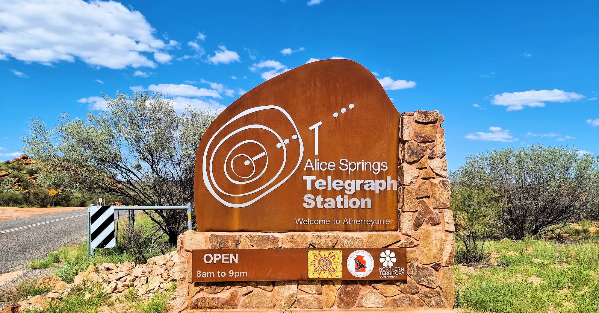
Alice Springs Telegraph Station Historical ReserveSpring with no water
Welcome to Atherreyurre
Located on the northern edge of town, the Alice Springs Telegraph Station Historical Reserve marks the original site of the first European settlement in the region and originally included the area now covered by the township of Alice Springs.
The original Alice Springs was a waterhole located some 3 km north of the present town. Named after Alice Todd (wife of Superintendent of Post and Telegraph Sir Charles Todd), the town was founded as a staging point for the overland telegraph line in 1870. The current Alice Springs began its history as a town named Stuart, a telegraph station on the Adelaide to Darwin line, what was once the end of the Ghan railway line. With its renaming and gender change, ‘The Alice‘… as it is affectionately known by many locals, is now the modern town in the middle of Australia that you see today.

The reserve is a popular spot for locals and tourists. Here visitors can learn some history, enjoy the l green lawns and facilities, as well as some of the walking tracks.

Battery Room – this building was built about 1880 as sleeping quarters for the linesmen. The men later moved into the police house when it was vacated in 1886. At the same time, the batteries were relocated from the Barracks to this building.
From the Alice Springs Telegraph Station Historical Reserve information signage.
This building was converted to a schoolroom when the telegraph station became an Aboriginal children’s home in 1932.
The Telegraph Station was one of twelve repeater stations constructed along the ‘Overland Telegraph Line’ in the early 1870s to relay messages between Darwin and Adelaide and is the best preserved station along the ‘Overland Telegraph Line’.
The completion of the line herald a new era for fast direct communication between Britain and her then independent Australian colonies.
Operating for 60 years, and then serving as a school for Aboriginal children, visitors today can view many of the restored stone buildings, including internal furnishing from the period 1895-1905. The Post and Telegraph Office continue to operate, but only on occasions of special historical significance.
The reserve includes a shaded lawns area with picnic and free electric barbeque facilities. There are also public amenities. There is a small cafe and kiosk with food, cold drinks and souvenirs.
Access
Located 4 km north of Alice Springs along Herbert Heritage Drive, off the Stuart Highway, the reserve is accessible to vehicles and coaches.
There is also a walking and cycling track into the Reserve from the Stuart Highway via Schwartz Crescent, and another track along the west bank of the Todd River, known as the ‘Riverside Walk’.
Source: Alice Springs Telegraph Station Historical Reserve & NT Govt Parks & Reserves
Walking Tracks
In addition to the two tracks leading from the Alice Springs town centre to the Alice Springs Telegraph Station, there are also a series of short, marked walks that can be accessed from the Trail Station Cafe area. Please note though that many of these tracks are shared with cyclists.
Alice Springs Telegraph Station – Attractions
- Riverside Walk
— To Park Boundary — 1.8 km — easy
— To Town (Todd Mall sails) — 3.3 km — easy
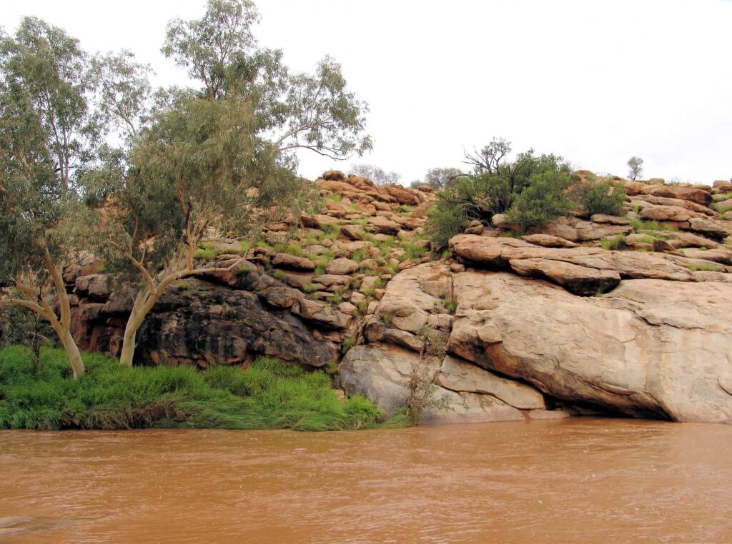
The shaded banks of the Todd River are often an ideal area to see the bird life that make their homes in the hollow branches of the River Red Gums. From the southern end of the picnic area, follow the western bank of the Todd River (usually dry), south towards Alice Springs, passing granite outcrops that are home to Euros and Black-footed Rock-wallabies. You may be lucky enough to see them in the early morning or late afternoon. At the Reserve boundary the track continues along the River into Alice Springs.
- Bradshaw Walk
— To Riverside Walk Junction — 2.4 km — easy to moderate
— Return to Information Shelter — 3.8 km — easy to moderate
You can join the trail at the Riverside Walk junction or start from the Reserve Information Shelter.
The Residence in the historic precinct was home for Thomas Bradshaw, a Postmaster at the Telegraph Station in 1890s, and his family. This walk crosses the car park and meanders through Acacia shrubland in the foothills between the River (usually dry) and the main ridge to the west. Rocky in patches, the track crosses creeks and ascends low, stony rises before it turns back toward the River, meeting the Riverside Walk junction, and returns to the Information Shelter.
- Stuart Walk
— To Park Boundary — 2 km — easy to moderate
— To Town (Todd Mall sails) — 4.4 km — easy to moderate
John McDouall Stuart led the first European exploration party into central Australia and established a route for the Telegraph Line. From the eastern side of the picnic area this walk crossed the Todd River, traversing ridges and gullies on the way to the southern boundary of the Reserve. The track winds through an Acacia shrubland with Mulga, Witchetty Bush and a variety of Senna species, before cresting a ridge with views of Alice Springs and the MacDonnell Ranges. At the Reserve boundary you can continue along the track to Alice Springs.
- Spencer Hill Walk
— To Park Boundary — 1.5 km — easy
— To Town (Todd Mall sails) — 3.5 km — easy
Baldwin Spencer recorded Dreaming stories of the Eastern Arrernte people from the area around the Telegraph Station site in the late 1890s. From the eastern side of the picnic area this walk crossed the Todd River and follows its eastern bank to Spencer Hill. Along the base of the foothills the walk goes through a magnificent stand of Ghost Gums. At the Reserve boundary you can continue along the track to Alice Springs.
- Larapinta Trail
— Section 1 to Simpson’s Gap — 23 km — moderate
— Section 2 — 204 km — grade varies
This trail takes you in sections through the West MacDonnell National Park.
For your safety, Walkers using the Larapinta Trail are strongly advised to heed all advice on the NT Government website. Information can be found:
Larapinta Trail Safety and Advice (if this link is not active, do an internet search on the NT Government website for further information.
Remember that Safety: It’s Your Responsibility.
- Trig Hill Walk
— Return by same track — 1.2 km — moderate
— Return by cemetery — 2 km — moderate
Once used as a survey point in mapping the area, Trig Hill is a high point in the Reserve that offers 360º views that take in the Telegraph Station, the Todd River and the MacDonnell Ranges. Follow the track to Alice Springs waterhole and continue on beside the fence line. The track traverses alluvial flats and low granite outcrops to the base of Trig Hill, where a short, steep climb leads to the summit. Return the way you came or continue on and return via the Cemetery.
- Cemetery Walk
— Return by same track — 1.4 km — easy
— Return by Trig Hill — 2 km — moderate
This walk takes you to the grave of five early residents of central Australia. Follow the walking track beside the entrance road for 300 metres tot he Larapinta Trail Information Shelter. The track traverses Acacia and Senna shrublands, crosses a dry creek bed and meanders around granite outcrops on the way to the Cemetery. Return the way you came or continue on and return via Trig Hill.
- Alice Springs Waterhole Walk
— 200 m — easy
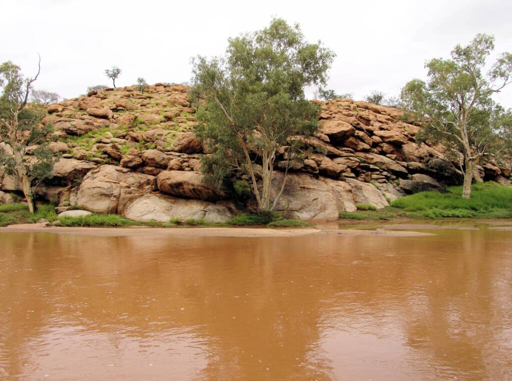
Limited surface water in central Australia has made this waterhole an important resource for both people and wildlife. The Eastern Arrernte name for the waterhole is ‘Thereyurre’. It was named ‘Alice Spring’ after the wife of the South Australian Postmaster General, in the mistaken belief that it was fed from a spring in the hillside behind it. Although during dry times water may not be visible, it is still present under the sand.
Source: Alice Springs Telegraph Station Historical Reserve Signage


Wigley Waterhole and Wigley Gorge
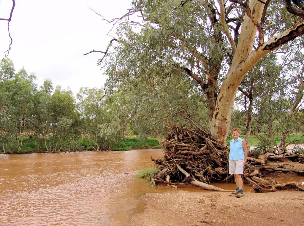
Nestled within the Old Telegraph Station Historical Reserve, Wigley Waterhole and Wigley Gorge is one of the locals favourite swimming spot during those long hot summers. Wigley’s (as it is more commonly known) is a hilly, rocky area providing a great place not only for swimming and relaxing by the waterhole, but also bike riding, four wheel driving and bush walking. Less than 15 minute drive from Alice Springs, access is from the Stuart Highway about 15 km north of Alice Springs, turn right and follow the dirt track along which you will see signs pointing the direction.
There is also a rain gauge above Wigley’s Waterhole and Weir that provides flood forecasting and information on any flows into Alice Springs, although sometimes forecast alert can be as short a time frame as 30 minutes, as was the case with the big flows in 1988.1
If you are planning a visit, make sure you check out their website:
Alice Springs Telegraph Station Historical Reserve
Footnote & References
- ABC Alice Springs – Reading the rain 18 November, 2008, by Alex Barwick Retrieved February 6, 2011, from http://www.abc.net.au/local/stories/2008/11/18/2423028.htm (link not active)
Alice Springs Telegraph Station Historical ReserveSpring with no water
Alice Springs AttractionsAlice Springs Desert Park Alice Springs Reptile Centre Alice Springs Telegraph Station Historical Reserve Alice Springs Waste Stabilisation Ponds Alice Springs Walks Untyeyetwelye • ANZAC Hill Araluen Cultural Precinct Bird Watching in Alice Springs and Central Australia Central Australian Aviation Museum The Gathering Garden John Flynn’s Grave Historical Reserve Kunoth Bore Olive Pink Botanic Garden Royal Flying Doctor Service National Road Transport Museum Women’s Musuem of Australia
Alice SpringsMparntwe Alice Springs Accommodation Alice Springs Pet Friendly Accommodation Alice Springs Art & Culture Alice Springs Attractions Alice Springs Directory Alice Springs Distance Alice Springs Festival & Events Alice Springs Flora and Fauna Alice Springs Fauna Alice Springs Flora Getting Around Alice Springs Alice Springs Aboriginal Tours Alice Springs Tours Alice Springs Tours – Other